|
general
information 2... [back]
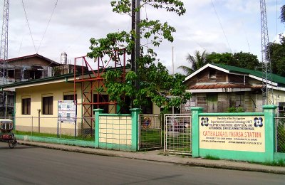
Catbalogan
PAGASA Station
H.
Climate and Rainfall
The province
falls under the 2nd and the 4th type of climate. Type II is characterized by
having no dry season with a very pronounced maximum rain period from December to
February. Minimum monthly rainfall occurs during the period from March to May.
Areas characterized by this climate are generally along or very near the eastern
coast, thus, open to the northeast monsoon. Municipalities at the southeastern
part of the province experience this type of climate.
Type IV
climate has no maximum rain and no dry season (rainfall is more or less
distributed throughout the year). This is an intermediate between the first and
second types of climate, although it resembles the second type more closely,
hence it has no dry season. Those areas located at the northwestern part of the
province have this type of climate that includes the municipalities of Gandara,
San Jorge, Pagsanghan, Tarangnan, Sta. Margarita, Sto. Niño, Almagro, Tagapul-an,
Calbayog City and portions of Matuguinao and San Jose de Buan.
Monthly and Average Rainfall in
Millimeters (2008-2012)
|
MONTH |
YEAR |
|
2008 |
2009 |
2010 |
2011 |
2012 |
|
January |
327.8 |
293.3 |
337.9 |
991.6 |
456.8 |
|
February |
1,111.0 |
349.7 |
7.9 |
135.1 |
372.6 |
|
March |
223.5 |
136.5 |
142.9 |
823.8 |
430.2 |
|
April |
198.1 |
296.6 |
63.7 |
173.9 |
128.0 |
|
May |
468.0 |
145.4 |
73.2 |
669.9 |
144.5 |
|
June |
364.5 |
550.0 |
99.9 |
235.8 |
261.7 |
|
July |
187.9 |
140.6 |
401.7 |
467.1 |
415.7 |
|
August |
236.6 |
247.4 |
281.8 |
245.5 |
18.7 |
|
September |
279.9 |
180.1 |
453.6 |
454.7 |
438.0 |
|
October |
276.1 |
260.0 |
348.9 |
402.2 |
435.7 |
|
November |
319.2 |
242.5 |
193.2 |
231.2 |
297.5 |
|
December |
422.4 |
208.8 |
248.9 |
396.4 |
248.9 |
|
Total |
4,415.0 |
3,050.9 |
2,653.6 |
5,227.2 |
3,648.3 |
|
Average |
367.9 |
254.2 |
221.1 |
435.6 |
304.0 |
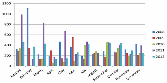
The average
rainfall in the past five (5) years (2008-2012) was 302.2 millimeters. The
highest rainfall was registered at 1,111 millimeters in February, 2008 due to
continued heavy rains during the northeast monsoon. The lowest rainfall for the
past five years was recorded in February, 2010 (7.90 mm.) because of the
occurrence of "El Niño" which lasted for five months (February-June). Fair
weather was noted in 2009 and 2011 except for the months of January and May at
the latter year which recorded quite high rainfall at 991.6 millimeters and
669.9 millimeters respectively. See Table above and Figure below.
Annual rainfall in 2011 (5,227.2 mm.) was the highest in the past 5 years
(2008-2012 mm.) which is nearly doubled from 2010 and likewise its average. High
rainfall was noted in the months of January (991.6 mm.), March (823.8 mm.) and
May (669.9 mm.).
Rainfall Pattern in Millimeter as
of 2008-2012
Climate scientists have declared
that climate change is upon us. And this global phenomenon that is happening now
has been observed to cause extreme weather events- droughts and intense tropical
cyclones/typhoons- that impact adversely on man and environment. What is more
appalling is the increasing frequency and intensity of these events that is
foreseen to make disastrous impacts on the climate sensitive sectors, the
agriculture, health infrastructure, coastal water and forestry resources.
The government is doing
considerable efforts necessary to prepare for these impacts- primary of which is
by incorporating disaster preparedness and adaptation in development planning
and step up investment in these areas.
Planning for disaster risk
reduction and climate change adaptation was initiated by the National Economic
and Development Authority (NEDA) with funding from the United Nations
Development Programme (UNDP) and Australian Agency for International Development
(AUSAID) and was implemented nationwide.
Initially, a disaster risk and
vulnerability assessment study was conducted to identify the multiple natural
hazards that affect the province and the effect of the occurrence of these
hazards on the vulnerable sectors.
The province's disaster risk and
vulnerability assessment (DRVA): The province is prone to three (3)
hydrometeorologic hazards namely flood and flashflood, rain induced landslides,
and storm surge, and three (3) geologic hazards or earthquake related hazards
namely ground shaking, liquefaction and earthquake-induced landslide.
Tropical Cyclones that affected
Samar Province
|
Name of Storm/Typhoon |
Date Occurred |
Storm Signal |
Maximum Wind Velocity (kph) |
Gustiness (kph) |
|
2005 |
|
Pepeng |
November
18,2005 |
2 |
180 kph |
80 kph |
|
2006 |
|
Agaton |
January 23,
2006 |
2 |
65 kph |
80 kph |
|
Caloy |
May 10,
2006 |
2 |
80 kph |
100 kph |
|
Domeng |
June 24,
2006 |
2 |
75 kph |
90 kph |
|
Henry |
July 29,
2006 |
2 |
65 kph |
80 kph |
|
Melenyo |
September
25-26, 2006 |
2 |
180 kph |
210 kph |
|
Senyang |
December 8,
2006 |
2 |
80 kph |
100 kph |
|
2007 |
|
Lando |
November
19, 2007 |
1 |
60 kph |
- |
|
2008 |
|
Bebing |
February
18, 2008 |
1 |
55 kph |
- |
|
Frank |
June 20,
2008 |
1 |
60 kph |
- |
|
Pablo |
September
29, 2008 |
2 |
75 kph |
90 kph |
|
Rolly |
November 8,
2008 |
1 |
55 kph |
- |
|
2009 |
|
Feria |
June 23,
2009 |
3 |
75-90 kph |
- |
|
Niña |
September
19, 2009 |
2 |
200 kph |
240 kph |
|
Peping |
October 1,
2009 |
1 |
60 kph |
- |
|
2010 |
|
None |
|
|
|
|
|
2011 |
|
Bebeng |
May 6-8,
2011 |
1 |
65 kph |
- |
|
Cheding |
May 23-27,
2011 |
2 |
180 kph |
- |
|
Egay |
June 17-19,
2011 |
1 |
63 kph |
- |
|
Juaning |
July 25-27,
2011 |
1 |
85 kph |
- |
|
Pedring |
September
25-26, 2011 |
1 |
75 kph |
- |
|
Sendong |
December
15-16, 2011 |
2 |
85 kph |
- |
Hydrometeorologic Hazards:
FLOODS. A flood is defined
as a "rise, generally brief, in the water levels in a stream to a peak from
which the water level receded at a slower rate" (UNESCO/WMO, 1992). Some floods
overflow the normal confines of a stream or other body of water and cause
flooding over areas which are not normally submerged. Floods are part of the
natural hydrological cycle and are generally an outcome of a complex interaction
between natural random processes in the form of precipitation with the basin or
watershed characteristics (World Meteorological Organization).
Floods in the province are
classified into three (3) as follows: (1) River flood – which is caused by the
overflowing of a river when run-off water exceeds the holding capacity of the
channels or depressions and covers adjacent to low-lying areas called the
"floodplain". (2) Flash flood – which is caused by a very short period of
unusually heavy rainfall in a mountainous or hilly area this usually occur in
the Catbalogan area; and (3) Coastal flood – which occurs when strong onshore
winds push the water inland and caused a rise in sea level and floods the
low-lying coastal areas.
At least 20 typhoons pass through
or enter the Philippine Area of Responsibility (PAR) every year and about three
(3) of these directly hit the province before moving away from the PAR to
another country or dissipate into the sea.
Typhoon that pass through, and
others that may not directly hit but the influence area are wide enough to
affect the province, bringing heavy and continuous rains would provoke flooding
on deltas or floodplains adjacent to the river systems provincewide. This is
aggravated by the lesser catchment capacity of the watershed areas, clogged
waterways, heavily silted rivers, and the restricted flow of floodwaters into
the sea.
Of the 951 barangays provincewide,
262 barangays are highly susceptible to flooding because the settlements are
situated adjacent to or within the floodplains, 165 barangays are moderately
susceptible and the rest are least susceptible to flooding.
FLASHFLOODS. Catbalogan
City, the capital of the province is highly susceptible to flash flooding
because of its proximity to a mountainous or hilly section of the land that
serves as the receiving portion of a bigger volume of rainwater that is released
into the long and winding Antiao River that passes through the city proper with
its tributaries within the city, before it discharges into the Maqueda Bay/sea.
This is aggravated by poor drainage system of the city, improper disposal of
garbage/waste materials that cause clogging of waterways and high tide
occurrence during heavy and continuous downpour.
RAIN-INDUCED LANDSLIDE. The
rainfall threshold that could trigger landslide is 100 millimeters of rain per
day. Steep slopes, thick soil or fractured rocks or tension cracks are
contributory factors. There are 229 barangays in the province that are highly
susceptible to rain-induced landslides because of their proximity to the
identified ground or environmental defects that is aggravated by the lack of
vegetative covers of these areas.
STORM SURGE. Storm surge
refers to the onshore rush of water into the coastal or low lying areas due to
abnormal water level caused by high wind and low pressure during typhoon
occurrence. The islands and coastal municipalities of the province are prone to
storm surge.
From 2008-2011, the local disaster
council have recorded about 50,000 families affected by hydrometeorologic
hazards with 6 fatalities and 5 injuries and around 95,000 of the province'
population are vulnerable to flooding. Damage to properties, infrastructures,
agriculture and the temporary stoppage of traffic along the Maharlika Highway
that cost the government millions of pesos have been reported.
Coastal erosion or shoreline
retreat is currently affecting many coastal areas in the Philippines. Natural
factors such as wind and waves, long shore currents and tectonic activities, as
well as anthropogenic factors such as dam construction, sand mining, coral reef
destruction, groundwater extraction, wetlands conversion, dredging of inlets for
navigation, and boat traffic have been identified as the factors contributing to
the hazard.
The impact of this coastal hazard
is expected to become more widespread due to climate change and sea level rise
as well as with the continuing urbanization and development of coastal
communities in the country. The hazard can inflict serious adverse impacts on
society. Land, properties, infrastructure, and natural resources, such as sandy
beaches, can be destroyed.
Landslide are described as
downward movement of a slope and materials under the force of gravity which
includes a wide range of ground movement, such as rock falls, deep failure of
slopes, and shallow debris flows. Landslides are influenced by human activity
(mining and construction of buildings, railroads and highways) and natural
forces (geology, precipitation, and topography).
What causes a landslide?
Landslides occur when masses of rock, earth or debris move down a slope. Gravity
acting on an overly steep slope is the primary cause of a landslide. They are
activated by storm, fires and by human modification to the land. New landslides
occur as a result of rainstorms, earthquakes, volcanic eruptions, and various
human activities.
The measures of landslides are
mudflows (or debris flows), which are flows of rock, earth, and other debris
saturated with water. They develop when water rapidly accumulates in the ground,
such as during heavy rainfall, changing the earth into a flowing river of mud or
"slurry". Slurry can flow rapidly down slopes or through the channels and can
strike with little or no warning at avalanche speeds. Slurry can travel several
miles from its source, growing in size as it picks up trees, cars and other
materials along the way (US FEMA. Understanding Your Risk: Identifying Hazard
and Estimating losses).
Rainfall thresholds for
landslides, based on the worldwide comparisons and trends, reveal that about
100mm of rainfall per day could trigger a landslide. Based on this observation,
independent studies by PHILVOLCS and their experts reveal that the amount of
rainfall that trigger landslides in Southern Leyte (2003) and in the Northern
Quezon and Aurora (2004) was more than three times the worldwide threshold.
Geologic Hazards:
EARTHQUAKE. An earthquake
is a weak to violent shaking of the ground produced by the sudden movement of
rock materials below the earth's surface (L. Bautista, 2008). Earthquakes are
caused either by the sudden movement along faults and trenches (tectonic), or by
the movement of magma beneath volcanoes (volcanic). Faults are fractures in the
earth's surface where rock movement has taken place and earthquakes produced.
Earthquakes can trigger hazards that can cause destruction to the lives and
properties such as ground shaking, ground rupture, earthquake induced
landslides, and tsunamis.
Samar is prone to earthquake
related hazards because of the presence of three faults/lineaments within the
provincial boundary. The longest fault line called the Southern Samar Lineament
1 spanning about 48 kilometers is located at the southern portion of the
province near Marabut and Basey. The second longest fault is called the Southern
Samar Lineament 2 that runs 30.5 kilometers long is also located near Basey and
Marabut. And the third fault called the Central Samar Lineament and about 29.5
kilometers long runs from Darahuway islands to Catbalogan city and San Jorge.
Several strong earthquakes,
ranging from intensity 6 to 7.8 in the Richter scale, have been recorded to have
struck near Samar from 1608 to 2012 but no death nor heavy damage to
infrastructure and properties have been reported.
Ground shaking is the main
hazard created by seismic earth movements. This term is used to describe the
vibration of the ground during an earthquake. During an earthquake seismic waves
travel rapidly away from the source and through the earth's crust. Upon reaching
the ground, they produce shaking that may last from seconds to minutes (Kramer,
1996).
Earthquakes strength is measured
in terms of either its magnitude or intensity. Magnitude measures the total
energy released at the earthquake's point of origin (below the earth's surface)
based on information derived from a seismograph typically reported in Arabic
numerals (e.g., 6.3, 7.2). Intensity is the perceived strength of an earthquake
based on relative effects to people and structures of the earth's surface. The
Philippines uses the PHIVOLCS Earthquake Intensity Scale (PEIS), which helps
explain the intensity assigned to a specified location based on observations
made on the consequences.
Based on the six "worst case"
scenarios simulated, Samar Province has a total 1,142 barangays and sitios out
of 951 barangays, sitios and islands with a very high level of earthquake
induced landslide susceptibility. The highest number of barangay which are
highly susceptible to ground shaking are in Basey, Paranas, Calbiga, Gandara,
Daram, Catbalogan and Calbayog.
Provincewide, a total of 1,142
barangays and sitios are ground shaking prone. It is worth mentioning however,
that out of the 26 municipalities/cities only the municipality of Tagapul-an is
not highly susceptible to ground shaking. About 98.19% of the total land area of
the province is exposed to ground shaking.
Within the province are three
earthquake faults/lineaments. The longest fault line is the Southern Lineament1
which spans about 48 kilometers, starting from the northwest portion of Giporlos
and running northwestward through the northeast of Balangiga, the western
portion of Llorente and Balangkayan, Eastern Samar to the northeastern tip of
Marabut and the western section of Basey. The second longest fault is the
Sothern Samar Lineament2 which is approximately 30.49 kilometers runs from the
southwestern tip of Marabut northwestward to the southwestern part of Basey. The
third fault is the Central Samar Lineament has an estimated length of 29.43
kilometers starts from Darahuway Islands runs along the central portion of
Catbalogan City northwestward to the central portion of San Jorge.
Liquefaction is a process
where particles of loosely-consolidated and water saturated deposits of sand are
rearranged into a more compact state. This results in the squeezing of water and
sediments towards the surface in the form of "sand fountain" and creating a
condition resembling "quicksand". In this phenomenon, the strength of the soil
is reduced to a point where it is unable to support structures Kramer, 1996).
Liquefaction commonly occurs in
areas that are water saturated (shallow water table), low lying and situated in
typically loosed (unconsolidated) foundation or in sandy or silty deposits.
Typical examples of these areas are river banks, abandoned rivers, flood plains,
coastlines and swamps.
The liquefaction encompasses
several related phenomena, among which are lateral spreads, subsidence and sand
boils. Lateral spread involves the horizontal displacement of surface blocks as
a result of liquefaction in a subsurface layer. Characterized by incremental
displacements during earthquake shaking, it can produce damage in the abutments,
foundations and superstructures of bridges, pipelines, bridge piers and other
structures with shallow foundations, especially those located near river
channels or canal banks on floodplains (Kramer, 1996).
The municipalities which are
moderately susceptible to liquefaction include all the towns' except Almagro,
Matuguinao, Sto. Nino, Tagapul-an, and Talalora. It is however worth mentioning
that the municipality of Tagapul-an is the only municipality in the province
that is not susceptible to any level of liquefaction. The high and moderately
susceptible liquefaction areas in the province are located near the river bank,
downstream and coastal area. About 40.16 percent (224,552.17 hectares) of the
total land area of the province is prone to liquefaction.
Summary Matrix for all Hazards by
Municipality
|
Municipalities |
Geologic Hazards |
Hydrometeorological
Hazards |
Others |
|
GS |
LIQ |
EIL |
Floods |
RIL |
Storm Surge |
Coastal Erosion |
|
1.
Almagro |
● |
● |
|
● |
● |
● |
|
|
2.
Basey |
● |
● |
● |
● |
● |
● |
● |
|
3.
Calbayog City |
● |
● |
● |
● |
● |
● |
|
|
4.
Calbiga |
● |
● |
● |
● |
● |
● |
|
|
5.
Catbalogan |
● |
● |
● |
● |
● |
● |
|
|
6.
Daram |
● |
● |
● |
● |
● |
● |
|
|
7.
Gandara |
● |
● |
● |
● |
● |
● |
● |
|
8.
Hinabangan |
● |
● |
● |
● |
● |
|
|
|
9.
Jiabong |
● |
● |
● |
● |
● |
|
|
|
10.
Marabut |
● |
● |
● |
● |
● |
● |
|
|
11.
Matuguinao |
● |
● |
● |
● |
● |
|
|
|
12.
Motiong |
● |
● |
● |
● |
● |
|
|
|
13.
Pagsanghan |
● |
● |
● |
● |
● |
|
● |
|
14.
Paranas |
● |
● |
● |
● |
● |
|
|
|
15.
Pinabacdao |
● |
● |
● |
● |
● |
|
|
|
16.
San Jose de Buan |
● |
● |
● |
● |
● |
|
|
|
17.
San Jorge |
● |
● |
● |
● |
● |
|
|
|
18.
San Sebastian |
● |
● |
● |
● |
● |
● |
|
|
19. Sta. Margarita |
● |
● |
● |
● |
● |
● |
● |
|
20. Sta. Rita |
● |
● |
● |
● |
● |
|
|
|
21. Sto. Nino |
● |
● |
|
● |
● |
● |
|
|
22. Tagapul-an |
● |
|
|
● |
● |
● |
|
|
23. Talalora |
● |
● |
● |
● |
● |
● |
|
|
24. Tarangnan |
● |
● |
● |
● |
● |
● |
● |
|
25. Villareal |
● |
● |
● |
● |
● |
● |
|
|
26. Zumarraga |
● |
● |
● |
● |
● |
● |
|
Note: GS - Ground Shaking
LIQ - Liquefaction EIL - Earthquake-Induced Landslide
RIL - Rain-Induced Landslide
Source: DRVA 2012
Liquefaction. Liquefaction
commonly occurs in areas that are water saturated (shallow water table), low
lying and situated in typically loosed (unconsolidated) foundation or in sandy
or silty deposits. Typical examples of these areas are river banks, abandoned
rivers, flood plains, coastlines and swamps.
The liquefaction encompasses
several related phenomena, among which are lateral spreads, subsidence and sand
boils. Lateral spread involves the horizontal displacement of surface blocks as
a result of liquefaction in a subsurface layer. Characterized by incremental
displacements during earthquake shaking, it can produce damage in the abutments,
foundations and superstructures of bridges, pipelines, bridge piers and other
structures with shallow foundations, especially those located near river
channels or canal banks on floodplains (Kramer, 1996).
A total of about 224,550 hectares
of the province is susceptible to liquefaction. This covers 16 municipalities
which are considered highly susceptible and 5 municipalities which are
considered moderately susceptible.
Earthquake-Induced Landslide (EIL).
Earthquake-induced landslide is the slope failure resulting from severe ground
shaking. This can be in the form of rapidly moving detached masses and bits of
pieces of solid and rock materials. In general, steep slopes with weathered
bedrock or soft rock units, hilly to mountainous areas exposed to high
precipitation rate, slope modified by roads cuts, quarrying operations, river
erosion and denuded forests are areas highly prone to landslide occurrences (Punongbayan,
1998).
Almost all of the municipalities
and cities in the province, except Almagro, Tagapul-an and Sto. Nino, are highly
susceptible to EIL.
Earthquake-induced landslide,
which is an earthquake associated hazard, is the slope failure resulting from
severe ground shaking. This can be in the form of rapidly moving detached masses
and bits of pieces of solid and rock materials. In general, steep slopes with
weathered bedrock or soft rock units, hilly to mountainous areas exposed to high
precipitation rate, slope modified by roads cuts, quarrying operations, river
erosion and denuded forests are areas highly prone to landslide occurrences (Punongbayan,
1998).
|