|
|
|
 IV. NATURAL RESOURCES IV. NATURAL RESOURCES
Limestones are
largely abundant in Samar
A. Land Resources
The province of Samar is
the largest of the three provinces in the Island of Samar with a total land area
of of 559,100 hectares or 5,591 square kilometers. This constitutes 41.23 percent of the island's
total land area and 25.93 percent of the total land area of the whole Eastern Visayas
region (see table below).
Fifty nine
percent (59.11%) or 330,500 hectares are in the mainland, while the remaining
40.89% covering 228,600 hectares are separate islands. The biggest mainland area
is Calbayog City (90,300 has.), followed with Basey (57,270 has.), Gandara
(43,280 has.) and Paranas (45,740 has.). The island towns are Almagro, Sto. Niño,
Tagapul-an, Zumarraga and Daram has the combined area of 22,860 hectares.
Land Area by
Province and Region
|
Province |
Land Area (km?) |
Percent to Total
Land Area (%) |
|
Biliran |
555.50
|
2.53
|
|
Southern Leyte |
1,734.80
|
8.05
|
|
Leyte |
5,712.80
|
26.49
|
|
Samar |
5,591.00
|
25.93
|
|
Northern Samar |
3,498.00
|
16.22
|
|
Eastern Samar |
4,470.75
|
20.73
|
|
Region |
21,562.85
|
100.00
|
A.1 Land Use
Land Use is the way in
which an area of land is actually put to use. The province of Samar has a total
area of 3,943.18 square kilometers of protection land and an area of 1,647.82
square kilometers of production land. The production land is comprised of 824.10 square kilometers of sustainable land, 822.51 square kilometers of under-used
land, and 1.20 square kilometers of over-used land.
One of the basic
indications of land use potential is the natural land slope categorized into 6
ranges. The first category is 3 percent slope or flat lands constituting a
total area of 73,314 hectares. The 8 percent slope is characterized as
gently sloping to undulating and is also highly suitable for agriculture and
non-agricultural development. This covers 28,529 hectares or 5.10 percent.
About 12.32 percent or 68,869 hectares fall within the 8 percent and under 18
percent category. Hilly to mountainous areas, are categorically within the
18 percent to 30 percent slope, comprise a total area of 122,004 hectares or
21.82 percent. Slopes above 50 percent are characterized to be very steep
and extremely rough mountainous areas, have a total area of 84,420 hectares or
15.07 percent (see table below).
Area Distribution by Slope Range
|
Slope Range |
Description |
Province
of Samar |
Percent to
Total |
|
0 - 3% |
Level to nearly level |
73,314
|
13.11
|
|
3 - 8% |
Gently slopping to undulating |
28,529
|
5.10
|
|
8 - 18% |
Undulating to Rolling |
68,869
|
12.32
|
|
18 - 30% |
Rolling to moderately steep |
122,004
|
21.82
|
|
30 - 50% |
Steep |
182,144
|
32.58
|
|
>50% |
Very steep |
84,240
|
15.07
|
|
Total |
|
559,100
|
100.00
|
The natural
land elevations of the province of Samar show that about 59.77 percent or 33,180 hectares are within 100 to 1,000 meters.
Based on the
climate and topography, the province is divided into five pedo-ecological
zones. Warm-cool upland and hilly lands accounts for 55.16 percent (380,370
ha.) of the province's total land area.
Erosion is a
critical environment phenomenon brought about by natural processes such as rainfall
intensities, floods, earthquakes, surface water run-off, and man-made activities
that are harsh on the environment such as illegal cutting of trees and shifting
cultivation or kaingin system, the province of Samar is dominated by slight
erosion covering a total land area of 262,402 hectares or 46.93 percent.
Severe erosion in the province covers a total land area of 129,721 hectares or
23.20 percent. Likewise, about 34.87 percent of the province's total land area
is degraded.
Topographical and
hydrological constraints impose limits to area in various parts of the province.
Only 33,037 hectares or 5.91 percent of the total land area impose no land
limitations. Watch movies and tv shows free.
A.2 Land Classification
The province's total land
area of 559,100 hectares is legally classified into the following: the
alienable and disposable land covering 348,789 hectares (62.38 percent), and
210,311 hectares (37.62 percent) of forest land.
A.3 Soil Type
Samar has four (4) main
groups of soils covering 553,088 hectares or 99 percent of the total land area
of the province, namely: a) soils at the eastern portion of the province; b)
soils at the central section; c) soils at the northwestern portion; and, d)
soils in the southwestern portion.
The first soil group
constitute about 140,234.5 hectares or one fourth (1/4) of the total soil cover.
Forests predominated once in this land area. Under this group, two soil
types are found, namely: Louisiana clay loan and mountain soil which is the
second largest soil type of the province, equivalent to 22 percent of the whole
soil cover.
The second group found in
the central section of the province comprises about 112,098.5 hectares.
This represents less than one fourth (1/4) of the total soil cover. The
soil typed predominating in this area is clay loam. This partly covers
forest areas.
The third soul
group which is the largest in area, constitutes about 234,092 hectares or 43.09
percent of the total soil cover. Under this group, the Catbalogan clay loam is
agriculturally the most important soil type representing about 34 percent of the
total area. The Tingib clay loam, Dolongan loamy sand, San Miguel clay loam,
Biga-a clay loam and Hydrosol make up the rest of the province's soil cover.
Most of these are found on plains and along the valleys where most of the
agricultural crops are grown.
Approximately
62,663 hectares or 11.32 percent make up the fourth soil group. About 33,060
hectares are found in the municipalities of Villareal, Catbalogan and the island
municipalities of Zumarraga and Daram. The rest are found in the southern tip
of the province. The table below shows the municipalities of the province with
the corresponding soil types.
Soil Type by Municipality/City
|
Municipality/City |
Soil
Types |
|
1. Almagro |
Unclassified |
|
2. Basey |
Catbalogan clay
loam, Faraon clay, Mountain soils, Tacloban clay loam,
Dolongan loamy sand, Tingib clay loam, Catb.-Tingib complex, Hydrosol. |
|
3. Calbayog City |
Catbalogan clay
loam, San Manuel loam, San Manuel sandy loam, La
Castellana clay loam, Silay loam, Hydrosol, Quingua clay loam, Pulupandan
sandy loam. |
|
4. Calbiga |
Catbalogan clay
loam, Faraon clay, Mountain soils, San Manuel loam,
Hydrosol, Tingib clay
loam. |
|
5. Catbalogan City |
Catbalogan clay
loam, Faraon clay. |
|
6. Daram |
Tacloban clay
loam. |
|
7. Gandara |
Catbalogan clay
loam, San Manuel loam, San Manuel clay loam, Bigaa loam,
Faraon clay. |
|
8. Hinabangan |
Catbalogan clay
loam, Faraon clay, Mountain soils, Hydrosol. |
|
9. Jiabong |
Catbalogan clay
loam, Faraon clay, Hydrosol. |
|
10.
Marabut |
Tacloban clay
loam, Mountain soils, Beach sand. |
|
11.
Matuguinao |
Faraon clay, San
Manuel loam, Mountain soils, Catbalogan clay loam. |
|
12.
Motiong |
Catbalogan clay
loam, Faraon clay, Mountain soils, Palapag clay loam,
Hydrosol. |
|
13.
Pagsanghan |
Catbalogan clay
loam, Bigaa loam, Hydrosol. |
|
14.
Paranas |
Catbalogan clay
loam, Faraon clay, Mountain soils, Hydrosol, Bigaa loam,
Ubay clay loam,
Bay clay loam. |
|
15.
Pinabacdao |
Catbalogan clay
loam, Tingib clay loam, Hydrosol. |
|
16.
San Jorge |
Catbalogan clay
loam, Bigaa loam, San Manuel clay loam, Faraon clay. |
|
17.
San Jose de Buan |
Mountain soils,
Faraon clay, Palapag clay loam. |
|
18.
San Sebastian |
Catbalogan clay
loam, Faraon clay, Hydrosol. |
|
19.
Sta. Margarita |
Catbalogan clay
loam, Bigaa loam, Silay loam, Hydrosol. |
|
20.
Sta. Rita |
Catbalogan clay
loam, Tacloban clay loam, Tingib clay loam, Faraon clay,
Hydrosol,
Catbalogan-Tingib complex. |
|
21.
Sto. Niño |
Unclassified |
|
22.
Tagapul-an |
Unclassified |
|
23.
Talalora |
Tacloban clay
loam. |
|
24.
Tarangnan |
Catbalogan clay
loam, Hydrosol. |
|
25.
Villareal |
Catbalogan clay
loam, Faraon clay, Hydrosol, Tingib clay loam, Mountain
soils. |
|
26.
Zumarraga |
Tacloban clay
loam, Ubay clay loam. |
B. Water Resources
The province has five (5) major
rivers: Basey River, Calbiga River, Ulot River, Gandara River and the Oquendo
Left/Right River. These rivers are utilized for irrigation and as transport ways
by the populace that lives in the interior barangays of the municipalities.
As a source of water supply, the
spring waters from underground sources flowing through rock formations supply
the rivers and creeks throughout the province. Some springs are tapped to
provide potable water to several municipalities and the excess water flow to the
rivers. The province has also several waterfalls (especially in Calbayog City)
for tourism and hydro-energy development.
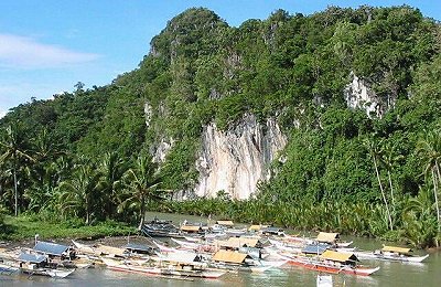
In terms of coastal and marine
resources, the province has a relatively long coastline, which extends over 300
kilometers from Calbayog City in the north down to the southernmost municipality
of Marabut. There are six (6) major fishing grounds with a combined area of
about 298 square kilometers considered with production potentials: Samar Sea,
Maqueda Bay, Villareal Bay, Zumarraga Channel, San Juanico Strait, and, San
Pedro and San Pablo Bay. These fishery areas, likewise, has large areas suitable
for brackish water fishponds development.
C.
Forestry
C.1
Forest Area and Timber Resources
Samar has a total forest
area of 167,300 hectares; 10,524 of watershed reserved and an area of 116,402
hectares of established timberland. It has also an area of 1,163 hectares
of reforestation.
Area
Distribution of Forestland by Classification
|
Classification |
Area (ha.) |
Percent to Total |
|
Alienable and Disposable |
348,789
|
62.33
|
|
Forest Land: |
210,311
|
37.62
|
|
Forest
Reserve |
12,744
|
6.06
|
|
Timberland |
172,250
|
81.90
|
|
National
Park |
840
|
0.40
|
|
Military
Reservation |
63
|
0.03
|
|
Watershed/Civil Reservation |
20,120
|
9.57
|
|
Fishpond |
4,294
|
2.04
|
|
Total |
559,100
|
100.00
|
The province's
remaining forest cover a total area of 167,300 hectares, dominated by second
growth forest (75.85%). Old growth forest accounts for only 13.63 percent of
the total area.
D. Mineral Resources
Hematite and magnetite
chromate, nickel and manganese are the major ore commodities of Samar. Copper,
minor zinc and lead are usually in the primary form of sulfide and associated
with abundant pyrite.
|
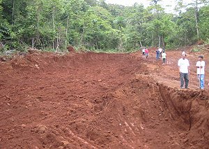
A
mining site for Bauxite deposits in Brgy. Canliges, Paranas, Samar. The
province has a 50-year moratorium on large-scale mining activities. |
Part of the
municipalities of Paranas, Hinabangan, San Jose de Buan and Brgy. Calapi,
Motiong are to be found the mineral deposits of copper, manganese and bauxite.
A wider copper prospect location covering an area of approximately 600 square
kilometers is situated at Bry. Lawa-an, Paranas, Samar, about 30 kilometers
southeast of Catbalogan.
Two area
surveyed for manganese deposits are Brgy. Maylobe in Paranas and Cataydongan in
San Jose de Buan, which cover an area of about 67 square kilometers. The
Cataydongan deposit is similar to that of Maylobe, however, the host is
different being pyroclastic and volcanic rocks.
Limestone widely outcrops
in Samar. In some areas, massive coralline limestone suitable as "marble"
for construction and indoor decorations are exposed for quarrying and
processing, which do not require sophisticated equipment.
The fossil dry caves are
the natural habitat of bat colonies and other animals. The accumulation of
the birds and bat excrement together with bones over long periods of time gave
the origin to guano; phosphate-rich deposits that are often suitable for
fertilizer.
The province has potential areas
for mining which are classified into metallic and non-metallic minerals. These
minerals are listed and classified on the table below.
Potential Mineral Resources
(Province of Samar)
|
Type of Minerals |
Location |
|
Metallic |
|
|
Bauxite |
Hinabangan, Paranas |
|
Copper |
Hinabangan |
|
Gold |
Gandara |
|
Manganese |
San
Jose de Buan, Calbayog City, Daram |
|
Pyrite |
Hinabangan |
|
Non-Metallic |
|
|
Green tuff |
Paranas, Gandara |
|
Limestone (Marble) |
Calbayog City, Marabut |
|
Peat |
Basey |
|
Red Burning Clay |
Gandara, Catbalogan, San Jorge, Sta. Rita, Calbayog City, Basey |
E. Fishery and Aquatic
Resources
|
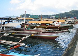
Commercial fishing is a
major activity in Samar. The province is a major supplier of fish
products to Manila. |
E.1
Fishing Ground
The province had a
relatively long coastline in the western side extending over 300 kilometers from
Calbayog City to the Southermost Municipality of Marabut, of which fishing became
its major activity. The bodies of water providing fishing grounds totaled to an
area of 298 square kilometers. It consists of the San Pedro Bay (2km2.),
Maqueda Bay (92km2.), Samar Sea (198km2.), Zumarraga
Channel (2km2.), and the Villareal Channel (4km2.).
In the table
below, fish production as of 2004 grew by 3.15% compared in 2003. Municipal
fishing garnered the biggest share at 18,285 metric tons or 70% of the total
production, followed with commercial fishing, 29.75% or 7,770 metric tons. Also
increased in fish production was the inland fishing, which was doubled (100%)
from its 2003 total fish catch.
|
Classification |
2004 |
2003 |
|
Production (MT) |
Production (MT) |
|
Commercial |
7,770 |
7,288 |
|
Municipal |
18,285 |
17,915 |
|
Inland |
66 |
33 |
|
Total |
26,121 |
25,236 |
|